

Chapter - 1 : 🇮🇳 India: Location & Physical Features
CBSE Class 7 Complete Geography Guide – Handcrafted Revision Notes & Conceptual Highlights by Pratap Sanjay Sir.
Location of India
- India is located in South Asia.
- Global Position: Located in the Northern and Eastern Hemispheres (Northeast angle / ईशान कोण).
- Latitudinal Extent: 8°4′ N to 37°6′ N (Southernmost point of territory reaches 6°45′ N at Indira Point).
- Longitudinal Extent: 68°7′ E to 97°25′ E.
- The Tropic of Cancer (23½° N) passes through 8 Indian states: Gujarat, Rajasthan, Madhya Pradesh, Chhattisgarh, Jharkhand, West Bengal, Tripura, and Mizoram.
- The Standard Meridian of India (82½° E) passes through 5 states: Uttar Pradesh, Madhya Pradesh, Chhattisgarh, Odisha, and Andhra Pradesh. It intersects the Tropic of Cancer at Baikunthpur/Surguja in Chhattisgarh. Madhya Pradesh and Chhattisgarh are the only two states traversed by both lines.
- India is the 7th largest country in the world by area (1. Russia → 2. Canada → 3. China → 4. USA → 5. Brazil → 6. Australia → 7. India 🇮🇳 → 8. Argentina → 9. Kazakhstan → 10. Algeria).
-
India is surrounded by three major water bodies:
- Arabian Sea in the west
- Bay of Bengal in the east
- Indian Ocean in the south
- India shares land boundaries with 7 neighboring countries: Pakistan, Afghanistan, China, Nepal, Bhutan, Bangladesh, and Myanmar.
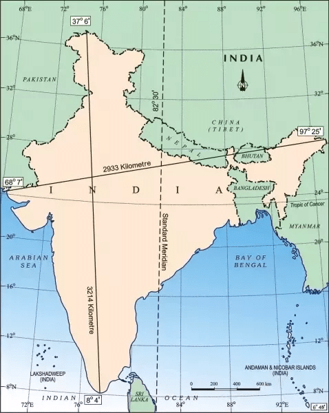
📏 Dimensions of India
- North to South 3,214 km
- East to West 2,933 km
- Distance from Equator 876 km
📍 Extreme Cardinal Points
- Northernmost Point: Indira Col, Ladakh / Siachen
- Southernmost Point (Overall): Indira Point (Great Nicobar, 6°45′ N)
- Southernmost (Mainland): Kanyakumari (Cape Comorin, 8°4′ N)
- Easternmost Point: Kibithu, Arunachal Pradesh
- Westernmost Point: Ghuar Mota (Sir Creek), Gujarat
Key Term: Kumari Shifting Cultivation
Shifting slash-and-burn agriculture traditionally practiced in the dense slopes of the Western Ghats is locally known as Kumari.
Physical Divisions of India
India is characterized by great diversity in relief features and can be divided into six major physiographic divisions:
These divisions differ significantly in their rock structures, landforms, altitude, climate, natural vegetation, and economic activities.
The Great Mountains of the North 🏔️
The northern mountains are mainly formed by the Himalayas, meaning "abode of snow" in Sanskrit.
Salient Features
- The Himalayas are geologically young fold mountains formed by tectonic collision.
- They stretch in an arc form from Jammu & Kashmir / Ladakh in the west to Arunachal Pradesh in the east (approx. 2,400 km).
- They act as an impenetrable natural barrier protecting India from freezing Central Asian polar winds.
- Perennial source of river systems like the Indus, Ganga, and Brahmaputra.
- Hosts perpetual snow peaks, high-altitude passes, and major glaciers such as Gangotri and Yamunotri.
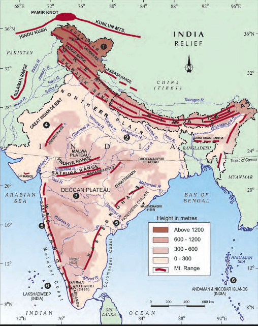
Three Parallel Ranges of the Himalayas
1. Himadri
(Greater Himalayas)
- Highest, innermost, and most continuous range.
- Average height exceeds 6,000 meters.
- Contains towering peaks like Mt. Everest and Kanchenjunga.
2. Himachal
(Lesser / Middle Himalayas)
- Lies directly south of the Himadri range.
- Average height ranges from 3,700m to 4,500m.
- Famous for scenic hill resorts (Shimla, Manali, Nainital).
3. Shiwaliks
(Outer Himalayas)
- Outermost and lowest range (900m – 1,100m).
- Formed by unconsolidated river sediments.
- Prone to earthquakes and landslides; famous for longitudinal valleys known as Duns (e.g., Dehradun).
⭐ Strategic & Climatic Importance of Himalayas
- Shields northern India from polar Siberian blasts.
- Intercepts Southwest Monsoon winds to cause rainfall.
- Perennial source of river irrigation and hydroelectric power.
- Rich in medicinal plants, timber, and biodiversity reserves.
Ladakh – The Cold Desert of India 🏜️❄️
- Ladakh is an ultra high-altitude plateau situated in the trans-Himalayan region.
- Enclosed between the Karakoram Range in the north and the Zanskar / Great Himalayas in the south.
- Falls in the rain-shadow area of the Himalayas, receiving negligible rainfall (less than 10 cm annually).
- Winters witness freezing sub-zero conditions (temperatures plunging below -30°C).
Vegetation & Flora
- Vegetation is extremely sparse due to aridity and bitter cold.
- Scanty alpine patches of grass and low shrubs for animal grazing.
- Willow and poplar groves grow along river channels.
People & Economy
- Pastoral nomadism & rearing of Yaks, sheep, and Pashmina goats.
- Pashmina wool is prized worldwide for exquisite shawls.
- Eco-tourism and Buddhist monastic culture attract global travelers.
Why is Ladakh categorized as a Cold Desert?
Reason: High altitude (above 3,000m to 8,000m) causing extremely thin, freezing atmosphere combined with negligible rainfall because it lies in the rain-shadow of the Greater Himalayas.
The Gangetic Plains 🌾
- Situated to the south of the Shiwalik foothills.
- Formed over millions of years by the deposition of fertile alluvial silt.
- Drained by the Ganga and its tributaries: Yamuna, Ghaghara, Gandak, Kosi, and Son.

Main Characteristics
- Level, flat terrain highly suitable for canal irrigation and rail-road connectivity.
- Referred to as the Granary of India producing rice, wheat, sugarcane, and oilseeds.
- Supports an extremely high density of population and vibrant industrial towns.
The Thar Desert 🏜️
- Located predominantly in western Rajasthan and extends across the border into Pakistan.
- Also known as the Great Indian Desert.
- Receives less than 15 cm of rain annually; characterized by undulating sand dunes (Barchans).
- Rivers in this region are mostly seasonal (ephemeral); Luni is the only major river.
Xerophytic Vegetation
- Plants with deep roots, fleshy stems, and thorny leaves to conserve moisture.
- Khejri, acacia (Babul), cacti, and dry shrubs.
Human Adaptation
- Pastoral herding of camels, cattle, and goats.
- The Indira Gandhi Canal has transformed north-western Rajasthan into productive farmland.
The Peninsular Plateau ⛰️
- The oldest landmass of India, formed from ancient crystalline, igneous, and metamorphic rocks (Gondwanaland fragment).
- Broad, shallow valleys and rounded hills with a triangular configuration.
- Endowed with mineral wealth including coal, iron ore, bauxite, and mica.
Two Main Divisions
Central Highlands
- Lies to the north of the Narmada River.
- Comprises the Malwa Plateau, Bundelkhand, and Chota Nagpur Plateau.
Deccan Plateau
- Lies to the south of the Narmada River.
- Flanked by the Western Ghats (Sahyadris) on the west and Eastern Ghats on the east.
Coastal Plains 🌊
The Peninsular Plateau is flanked by narrow strips of flat coastal plains on both the Arabian Sea and Bay of Bengal margins:
Western Coastal Plains
- Sandwiched between Western Ghats & Arabian Sea.
- Narrow, submerged coastline with natural harbors.
- Sections: Konkan Coast (north), Kannada Coast (central), Malabar Coast (south with lagoons/kayals).
Eastern Coastal Plains
- Located between Eastern Ghats & Bay of Bengal.
- Wider and continuous plains.
- Features massive deltas of Mahanadi, Godavari, Krishna, and Kaveri.
- Sections: Northern Circars (north) and Coromandel Coast (south).
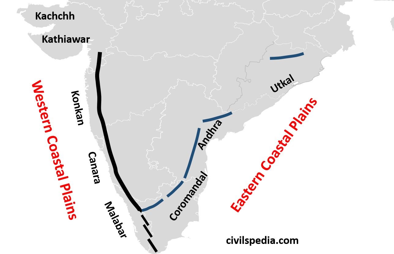
⭐ Key Differences: Western vs. Eastern Plains
| Features | Western Coastal Plains | Eastern Coastal Plains |
|---|---|---|
| Sea Boundary | Arabian Sea | Bay of Bengal |
| Width | Narrow (approx. 50 km) | Wide (100–120 km) |
| Delta Formation | Rivers form Estuaries (Narmada, Tapi) | Rivers build large, fertile Deltas |
| Regional Names | Konkan & Malabar | Northern Circars & Coromandel |
Islands of India 🏝️
India has two prominent archipelagos located in its bordering waters:
Andaman & Nicobar Islands
- Located in the Bay of Bengal.
- Submerged peaks of an underwater mountain range (Arakan Yoma extension).
- Home to India's only active volcano: Barren Island.
- Dense equatorial rainforests and Indigenous tribal reserves.
Lakshadweep Islands
- Located in the Arabian Sea off the coast of Kerala.
- Formed of coral reefs / atolls.
- Capital is Kavaratti; total area of just 32 sq. km.

Aravalli Hills
- The Aravalli Range is one of the oldest fold mountain ranges in the world (heavily eroded/relict).
- Extends from Gujarat across Rajasthan up to Delhi (Delhi Ridge).
- Highest peak: Guru Shikhar (1,722 m) in the Mount Abu range.
- Acts as a physical barrier preventing the eastward spread of the Thar Desert into the fertile Gangetic basin.
.png/1766217062.png)
The North-Eastern Hills (Purvanchal) 🌳
Beyond the Dihang gorge in Arunachal Pradesh, the Himalayas bend sharply southwards along the eastern border forming the Purvanchal Hills:
📝 Super-Quick Summary Revision
| Physical Division | Prime Geological Feature |
|---|---|
| Great Mountains of North | Young fold mountains, glaciers, perennial river origins |
| Northern Gangetic Plains | Flat, deep alluvial deposits, highest population density |
| Great Indian Thar Desert | Arid sandy expanse, sand dunes, xerophytic vegetation |
| Peninsular Plateau | Ancient Gondwana crystalline rocks, abundant mineral reserves |
| Coastal Plains | Narrow Western coast (estuaries) & wide Eastern coast (deltas) |
| Island Archipelagos | Andaman & Nicobar (Submerged peaks) & Lakshadweep (Coral reefs) |
⭐ Top 12 Exam One-Liners
- India is located in South Asia, in the Northern & Eastern hemispheres.
- The Himalayas are young fold mountains running 2,400 km in an arc.
- Ladakh is known as the Cold Desert because of high altitude & aridity.
- The Gangetic Plains are fertile due to continuous alluvium deposition.
- The Thar is India's largest desert, bordered by the Aravallis.
- Peninsular Plateau is the oldest landform of the Indian subcontinent.
- Western Coastal Plains lie along the Arabian Sea (Konkan & Malabar).
- Eastern Coastal Plains lie along the Bay of Bengal (Circars & Coromandel).
- Lakshadweep consists mainly of coral islands in the Arabian Sea.
- Andaman and Nicobar Islands contain Barren Island, India's active volcano.
- The Aravallis are one of the world's oldest relict mountain ranges.
- Tropic of Cancer (23½° N) passes through exactly 8 Indian states.
Notes Curated by Pratap Sanjay Sir
Specialist in NCERT Social Science & Geography curriculum for CBSE students. Print or bookmark this page for rapid revision during exams.


0 Comments